
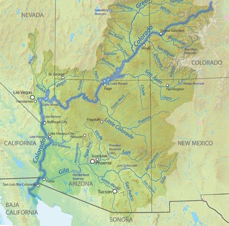
The Colorado River starts as a mere trickle in Colorado at La Poudre Pass near the Continental Divide. As the stream slowly winds its way down through the Rocky Mountains, small tributaries and other smaller rivers gradually builds the river wider, deeper and more rapid. As it proceeds through its 1,450-mile journey, it passes through the states of Utah, Arizona, Nevada and California on its way to the Sea of Cortez between Baja California and Mexico where its journey ends.
Along its way, the Colorado River takes on different personalities and attitudes from smooth flowing water and tranquil pools to filling lakes and turning into adrenalin provoking whitewater rapids. It is one of the most beautiful rivers in the country and runs through diverse and unique landscape including the Grand Canyon. During its long course to the sea, the Colorado River features a wide variety of water-recreation adventure from shaded beaches, casual swimming, camping, power boating, and house boating to extreme river rafting.
Flowing Through Northern Arizona
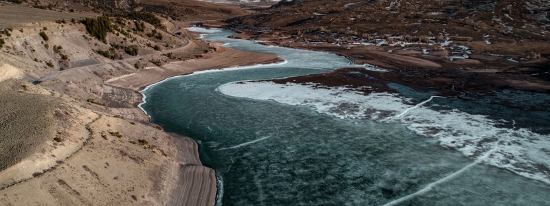
After leaving Colorado, the Colorado River continues through Utah to fill Lake Powell which sets on the border between Southern Utah and Northern Arizona Lake Powell is the second-largest man-made lake in the country created by the Glen Canyon Dam. This massive lake is about 280 miles long with almost 2,000 miles of shoreline. Known as the “Houseboat Capital of America”, one could spend weeks on Lake Powell and never see the same area twice. With several marinas, a resort and expansive natural camping areas, the lake is an outdoor paradise that includes power boating, water-skiing and fishing.
Water from Lake Powell continues to flow through the spillways of Glen Canyon Dam as the Colorado River continues its journey. Just below the dam, the river flows past Lee’s Ferry which is known as one of the best rainbow trout fishing spots in the country. It immediately flows through Vermillion Cliffs and Marble Canyon as it enters the eastern end of the of the Grand Canyon, one of the Seven Wonders of the World.
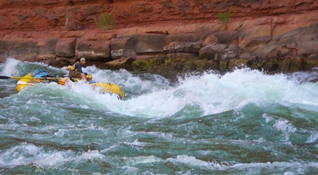
The Colorado River is responsible for carving the Grand Canyon over millions of years. Many are lucky to raft through portions of the Canyon to experience its inner beauty looking up the massive canyon walls. The river alternates from smooth flowing waters to breathtaking white-water rapids as it makes its way through 277 miles of Grand Canyon.
After leaving the Grand Canyon, the Colorado River flows into Lake Mead which begins to stage the river’s turn south into the Southern Colorado River Basin. Lake Mead is considered the largest man-made lake in the United States which covers about 247 square miles of water surface area. Although its surface area is smaller than Lake Powell, Lake Mead is deeper and has larger water capacity.
Lake Mead, who sets on the border of both Nevada and Arizona was created with the building of Hoover Dam to produce hydroelectric power electricity and control flooding and provide irrigation water. Hoover Dam, also known as Boulder Dam, was completed in 1936 during the Great Depression. Over 100 workers died building the dam which has become a major tourist attraction. Read more about Hoover Dam.
Colorado River Turns South
As it continues through the spillways of Hoover Dam, the Colorado River turns south, early during the flow, the river separates Nevada from Arizona and soon becomes the dividing border between California and Arizona. The river flows through deep canyon walls that opens-up to views of the desert and distant mountains. It flows gently through marsh areas and protected wilderness.
The Colorado River then creates Lake Mohave, a large popular boating and fishing lake just north of Laughlin, Nevada and Bullhead City, Arizona. Laughlin is known as “Little Las Vegas” with many casinos along the edges of the river. In fact, water-taxis take passengers from casino to casino. When not gambling, tourists enjoy the water adventures of powerboating and water-skiing.
On To Lake Havasu and Points South
The Colorado River flows through beautiful Topock Canyon as it continues for about 58 miles from Laughlin NV to Lake Havasu, AZ. Formed by Parker Dam, Lake Havasu is about 45 miles long with over 400 miles of shoreline. It is the most visited lake in Arizona, attracting more that 2.5 million visitors every year. Its crystal, deep blue waters with its coves and calm surface makes it ideal for boating, water-skiing, fishing, and camping.
Lake Havasu City, Arizona, which is known for the being the spot that that now claims the historic London Bridge which was transported from London and reconstructed piece-by-piece on the lake’s eastern shore as the crossover to Lake Havasu Island.
During spring-break, the coves, shores and nightlife venues are filled with college students taking the much need break from school. Lake Havasu is rated as the fifth most popular spring break destination in the country. These kids can get kind of rowdy as pods of boats gather in the coves for continuous party time. You’ll discover a constant parade of boats filled with students rounding a slow pace under the London Bridge.
In addition to this motorized recreation, Lake Havasu is also a popular sunbathing spot. Sandy beaches line much of its shores and are great spots to read a book, soak up some sun, and take a dip in the refreshing waters. If you choose to swim in an unsupervised swim area, be wary of the speeding boats. They sometimes get too close for comfort, so it is necessary to stay alert.
The waters of the Colorado River and of Lake Havasu are also great for fishing. Bass, catfish, panfish, and carp are only a few of the types of fish that can be found in the waters. Many visitors and residents enjoy casting lines out into the lake from boats, but the fishing from the shore can often be just as good. Boat rentals are available and offer an easy way to row (or power) yourself into a better fishing spot.
Because Lake Havasu is part of the Colorado River, Lake Havasu City is a great “home base” for many other activities on the river. Many other fun portions of the river are a close drive from Lake Havasu. The Hoover Dam and Lake Mead, Lake Mojave, and the casino-filled town of Laughlin are all north of Lake Havasu City and offer plenty in the way of river fun.
To the south, a variety of wildlife refuges with somewhat restricted access are a top- notch place to take in the natural beauty of the area. Below Parker Dam is what’s called the “Parker Strip” which is also a haven for boaters and water-skiers.
Nearing The End of Its 1450 Mile Journey
From Lake Havasu and Parker, Arizona, the Colorado River continues for about 123 miles to Yuma, Arizona where the river water is diverted through canals to provide irrigation for agriculture that heavily grown in that area. Since Yuma lies very close to the border with Mexico, the Colorado River soon flows into the Sea of Cortez between Baja California and Mexico.
Having originally began high in the mountains of Colorado it has now ended its long and glorious journey. Along the way, it has covered five states, gone through the Grand Canyon, created many lakes and continues to provide a wealth of water-recreation, incredible sights and amazing vacation adventure.
Lower Colorado River Towns & Lakes
It took nature millions upon millions of years. But she sculpted the ultimate water-recreation playground of the southwest. An outdoor mecca of sparkling river and lakes that beckons millions of vacationers to more fun than could be imagined. The genesis of the Colorado River begins high in the mountains of Colorado. As it flows eastward through Utah and Arizona through the Grand Canyon it turns south to Hoover Dam which forms Lake Mead, the largest manmade lake in the country. This lake is so vast, you’ll hardly notice the gazillions of speed boats, house boats, sail boats, jet-skis and fishing boats.

Now the engineering masterpiece, Hoover Dam stands tall, glorious and bold as it watches its river water head to Lake Mohave through picturesque canyons, stately Saguaro, marsh habitat and wildlife such as Bighorn Sheep. Davis Dam creates the lake and separates Bullhead City, Arizona from Laughlin, Nevada, the “Little Las Vegas” on the Colorado banks.
The Colorado River continues uninterrupted from Davis Dam at Laughlin to Lake Havasu City passing through Topock Gorge and the Havasu National Wildlife Refuge until it reaches the centerpiece of this Lower Colorado River Area, 45-mile-long Lake Havasu with its 450 miles of shoreline. Parker Dam, the world’s tallest dam creates Lake Havasu, often called the “Watersports Capital of America”.
A 16-miles stretch of the river called the Parker Strip runs below Parker Dam that has become a popular destination of Snowbirds that escape to the pleasant weather during the eastern cold winters. The entire 165-mile water-recreation corridor on the mid lower Colorado River Valley is covered with a wealth southwestern water oasis. Boat launches, marinas, restaurants, bars, college spring break hideaways, nightlife, campgrounds, rv parks, remote camping sites, vacation rentals, boat rentals, hiking trails and even gambling casinos.
The river continues for hundreds of miles through Yuma, Arizona as it makes it way to its final destination, the Colorado River Delta as it flows into the Sea of Cortez that sets between Baja California and mainland Mexico.
Towns and Lakes
Boulder, Nevada
- Hoover Dam
- Lake Mead
Laughlin, Nevada and Bullhead City, Arizona
- Davis Dam
- Lake Mohave
Lake Havasu City, Arizona
- Parker Dam
- Lake Havasu
Parker Strip
- 16-mile segment of river