

Scenic drives allow visitors to see some of Arizona’s varied geography and spectacular scenery. These drives may be found throughout the state, and they include everything from lava flows and cactus gardens to canyon rims, mesa tops, and pine forests.
Hit the road and take in the views — from scenic highways to lesser-traveled back roads, we have our favorite scenic drives in the Grand Canyon state. The following are just a handful of the routes you can take to see Arizona’s breathtaking scenery.
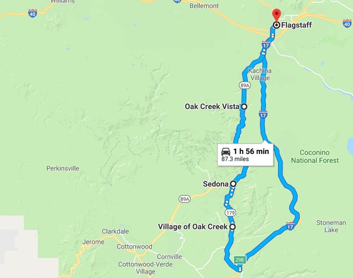
Oak Creek Canyon Scenic Drive
- Road: Highway 89A
- Length: 14.5 miles
Oak Creek Canyon is a stunning stretch of natural splendor on a meandering road that climbs 4,500 feet from Sedona to the top of the Mogollon Rim. The Oak Creek Canyon Scenic Drive is located on Route 89A between Sedona and Flagstaff, Arizona. Rand McNally named it one of the top five most scenic drives in America.
Whether you’re descending down highway 89A towards Sedona or ascending up to Flagstaff, this road is one of the most scenic routes in the state. The lush greenery of Oak Creek Canyon provides a canopy of pine and oak, occasionally opening up for some epic views of red rock. Want more than just the drive? Stop at Harding Spring to fill up on some fresh spring water, or take a dip in Oak Creek at Slide Rock State Park.
Passengers have the edge in terms of viewing. There are a few hairpin twists and switchbacks on the route that require the driver’s entire concentration. In any event, there are numerous places along the route to stop and take in the beauty and enchantment that Northern Arizona has to offer. Make a visit to Slide Rock, a favorite summer water activity spot.
Map of Oak Creek Canyon Scenic Drive
Much of this twisting path follows the fault line of Oak Creek Canyon’s 2000-foot depth before plunging into a virtual forest of desert rock formations. Travelers who wish to stop along the road for a picnic or hike must have a Red Rock Pass or an America the Beautiful Pass to park. In fact, exploring is highly suggested, with attractions varying from the Pumphouse Wash Bridge to Slide Rock State Park.
Apache Trail Scenic Drive
- Road: State Route 88
- Length: 41.5 miles
The Apache Trail, also known as State Route 88, is not for the faint of heart or those terrified of heights. It cuts across the desert at first but soon begins to bend sharply, rising and falling with the landscape’s hills and valleys. It is preferable to have a truck traverse the entire graded-dirt route, although a car will suffice.
Following the Salt River through the Superstition Mountains, the Apache Trail offers an authentic Sonoran Desert experience. If you start from Apache Junction, only about half the trail is paved, making it one of the more rugged drives on the list. It features stunning views of Canyon, Apache, and Roosevelt lakes.
Tortilla Flat is a must-visit along the way. Tortilla Flat was a changing station where mules hauling loads of building material for Roosevelt Dam were traded for fresh mules a century ago. There is now a museum, a historic post office, and the Superstition Saloon, a popular restaurant and watering spot. Try the ice cream with prickly pear.
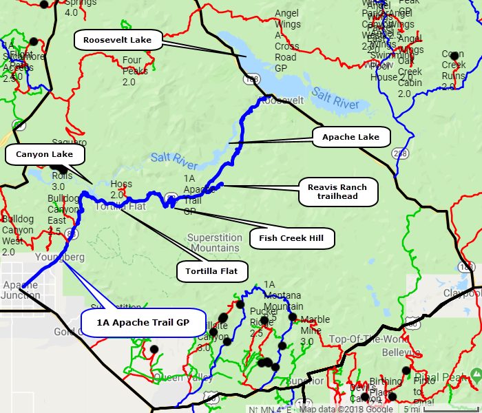
Former President Teddy Roosevelt once proclaimed that the Apache Trail was “one of the most gorgeous, best-worth-seeing vistas in the world,” and it is undeniably a scenic drive full of natural and man-made treasures to see. There’s much to keep visitors entertained, from the historical gold mine in Goldfield Ghost Town to the magnificent Superstition Mountains. However, the first section of the Apache Trail is paved, whereas the second leg is not.
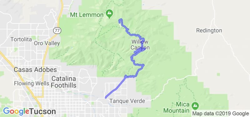
Sky Island Scenic Byway
- Roads: Forest Service Road 833, 10 and 11
- Length: 27.2 miles
Pack a picnic and drive 25 miles northeast towards the Catalina Highway, then west for 7 miles to access Windy Point Vista. A short pedestrian trail leads to the overlook, which offers panoramic views of Tucson and the Pusch Ridge Wilderness. The elevation range exhibits different geography and species. Before proceeding on the byway to Summerhaven or Ski Valley, enjoy a leisurely meal while watching the sunset.
Also known as Catalina Highway, this scenic road climbs steeply out of the desert floor to the heavily forested Mt. Lemmon. With a 6,000-ft. elevation gain, the variety of vegetation on the ascent is surreal. Beginning with classic desert vistas, the drive takes you to a lush, cooler forest of conifer and ponderosa pine. The temperatures drop dramatically as you climb, making it perfect for escaping southern Arizona’s heat in the summer months.
The Sky Island Byway, which climbs a steep highway to Mt. Lemmon, is one of Arizona’s most scenic but difficult cycling routes. Because the steep climb up is exceedingly challenging and the ride down requires cautious riding on a high downhill gradient, the ride is popular among serious riders who want to push themselves. Temperatures drop dramatically when you leave the desert bottom and ascend into the mountain range, and summer thunderstorms can also induce substantial temperature decreases. Mount Lemmon Ski Resort offers lodging and dining options.
Map of Sky Island Scenic Byway
This route leads adventurers on a 6,000-foot rise that simulates experiencing all four seasons in one trip, but the sights at the top make the temperature shift and ear-popping height worth it. There are no petrol stations along the route, so travelers should bring a full tank of gas, plenty of water, and even a jacket. Windy Point and Geology Vista are popular destinations for photographers, although there are numerous more places to practice, such as the Butterfly Trail and the Mt. Lemmon Sky Center.
Coronado Trail National Scenic Byway
- Roads: Highway 191 and 180
- Length: 103 miles
Highway 191 is one of the lesser-traveled scenic drives in the state, perfect for solitude-seekers. With a 4,300-ft. elevation gain and some winding switchbacks, this road rises up from desert scrub to the White Mountains of northeastern Arizona. In addition to the heavy pine forest, there’s an abundance of Aspens along this road, making it a golden spectacle during the fall.
The Coronado Trail Scenic Byway goes across Arizona’s White Mountains for 120 kilometers. The path is riddled with difficult switchbacks, hairpin curves, steep gradients, dramatic drop-offs, and spectacular beautiful vistas. It’s in a remote area of east-central Arizona.
Begin your adventure along the Coronado Trail in Springerville, Arizona, at the Madonna of the Trail Monument. The ride south along the route takes about four hours. Because there are few services along the way, start with a full tank of gas and keep an eye out for the numerous wildlife. Deer, elk, and other four-legged animals can arrive unexpectedly on the road.
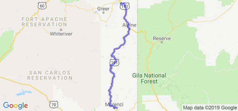
This byway may not experience much traffic, but it boasts enough beautiful scenery to make the trek worthwhile. There’s always something to keep visitors on their toes, from the Morenci Copper Mine Overlook, which offers a glimpse of the largest copper mine in the U. S., to the Chase Canyon with its hairpin bends. The highlight of the drive, though, is the volcanic Escudilla Mountain, Arizona’s third-highest peak at 10,912 feet.
Kaibab Plateau Scenic Drive
- Road: Highway 67
- Length: 30 miles
Highway 67 is a gentle byway traveling through a variety of forests, small ponds, and subalpine meadows on the Kaibab Plateau. The road winds 30 miles south down to the North Rim of the Grand Canyon, which sees significantly less traffic than the popular south rim. Deer and wild turkeys are not rare sights along this road, so keep an eye out for some wildlife. Note: Highway 67 is generally closed from November through mid-May due to heavy snowfall.
Many places along the Kaibab Plateau-North Rim Parkway allow you to get out, stretch your legs, and hike to spectacular overlooks of the Grand Canyon. The Grand Canyon is the world’s most spectacular natural wonder, and the adjacent Kaibab National Forest is home to a variety of native forest fauna. Keep a watch out for enormous, soaring birds, such as the endangered California condor, which has recently been brought to this area.
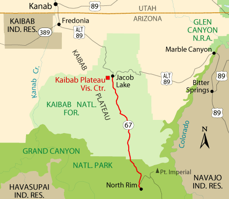
Map of Kaibab Plateau Scenic Drive
Along the route, stop at the Grand Canyon Lodge to take photos of the North Rim or try one of the hiking paths, which range from simple to difficult. Following that, Point Imperial provides views from the region’s highest elevation, where not only the Grand Canyon but also the Navajo Nation Reservation and the Colorado River may be seen.
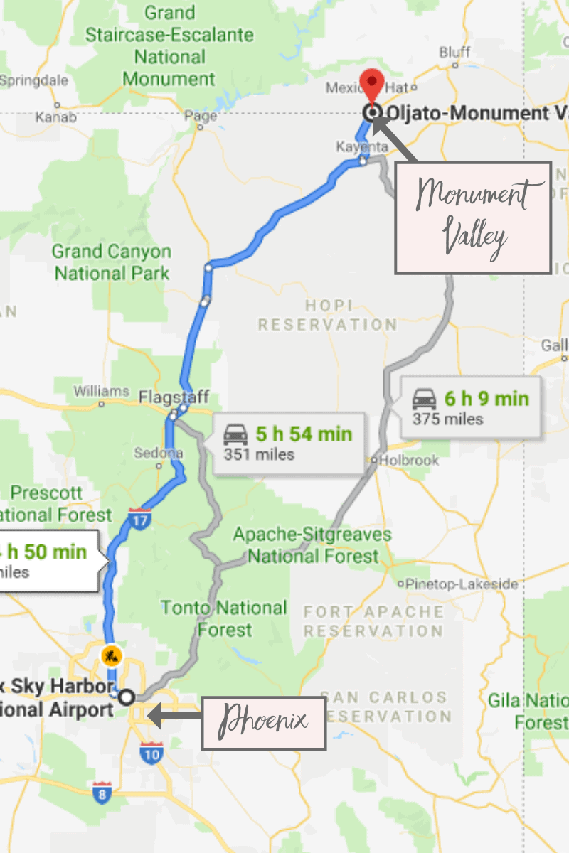
Monument Valley Scenic Road
- Road: Highway 163
- Length: 27.7 miles
Monument Valley is perhaps one of the most iconic landscapes of the American West. What better way to enjoy it than to drive right through it? Highway 163 does just that, traversing through the sparsely open spaces, which are sporadically broken up by the towering structures of sandstone that comprise this alien landscape. You can get an even closer look by entering Monument Valley Navajo Tribal park and driving the additional 17-mile loop.
Monument Valley’s scenic drive comprises 11 numbered stops, which are marked on the free map given by the Visitors Center. To get the most out of the experience, allow at least two to four hours. The Monument Valley road levels off after traversing the steep (and occasionally bumpy) initial 1/2 mile down Mitchell Mesa into the valley. Although you may read that a 4-wheel-drive car is required, this is not the case. The general admission fee to drive the 17-mile scenic loop route is $20 per car for up to four people; children under the age of nine are free.
Map of Monument Valley Scenic Road
The beauty of the many rock formations viewed along the Monument Valley trail may be appreciated by anyone. Many of the formations, like Elephant Feet and Chaistla Butte, will look familiar from the movies, but there are numerous other jagged shapes to entertain visitors. There are also options to extend the journey by visiting the Navajo National Monument, Gooseneck State Park, and the Valley of the Gods.
Final Word
These Arizona scenic drives offer the greatest way to see everything Arizona has to offer. All too frequently, tourists get wrapped up in things like making excellent time or sticking to a schedule, which only serves to speed them past wonderful sights and unusual activities. Try one of these picturesque drives if you want to properly appreciate Arizona’s diverse terrain, which is far from merely a monotonous, scorching desert.