
Best Arizona Easy Hikes
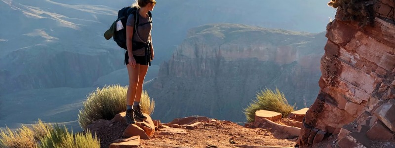
Arizona has a lot of natural beauty to offer, from the depths of the Grand Canyon to the waterfall oases that surround it, to the red cliffs of Sedona and the pine tree forests around Flagstaff. You can explore the waves, hoodoos, cliffs, and slot canyons formed by millions of years of wind and water erosion in this state, as well as the barren deserts and towering cacti to the south.
Living in Tucson, most of the hikes we do are around this area, but we also do other day trip hikes in Phoenix, Sedona, and Prescott. Today, we’d like to share with you some of our favorite hikes in Arizona that are perfect for if you want something short and sweet, enjoyable, and with views to die for.
Best hiking in Phoenix, AZ
Pinnacle Peak Trail
This trail is one of the most popular and most busy trails in the northern Scottsdale area of Phoenix and rightly so. It’s the perfect length, challenge, and fun for beginners. It’s super easy to follow the trail because there’s not many trees around – it’s clear, well marked, and honestly just follow the line of people ahead of you. There are gorgeous views of mansions all around you. There is a large parking lot, but of course at peak times it will be pretty busy so consider going early. The only downfalls: it’s busy and this trail does not allow dogs.
All Trails link and stats: 4mi out & back trail with elevation gain of 1,033 feet
Black Canyon Trail: Rock Springs
This trail is a hidden gem and never very busy. It’s a bit farther north in Phoenix so too far for many hikers. But since we live up this way, it’s one of our favorites. It’s clearly marked, has beautiful canyons, and at the end of the portion we do there’s a creek. Dogs are allowed so we love to let Forester pounce around in the water to cool off before we turn around and head back to the car. It’s an easy hike and just the right distance from the lot to the creek and back.
All Trails link and stats: 30.6mi point to point trail, but we always just do a short ~3mi portion out & back trail from the parking lot at Rock Springs
Sidewinder & Ocotillo Trail Loop
This trail is an easy loop and pretty flat but with pretty cacti and views of north Phoenix. Depending on the time of year, you’ll get to see pretty wildflowers. Many mountain bikers like this trail since it’s fairly flat and easy. The parking lot is huge so you won’t have an issue getting parking. Be sure to bring a hat and plenty of water because it’s not a shaded trail at all!
All Trails link and stats: 5.2mi loop with elevation gain of only 531ft
Dragonfly Trail
What a gem this trail is up in the Cave Creek area. Each time we’ve gone there’s only a few other cars there in the dirt lot. Unlike the other trails near it, this one is free. And it almost feels as if you’re stepping into the midwest temporarily. Most Arizona trails just have cactus everywhere, but this trail is filled with a canyon of huge trees, birds, and a creek. It’s a short hike, but every single moment it’s beautiful. It’s dog-friendly so we love to let Forester swim there, but there’s only enough water to swim if it’s recently rained so plan accordingly. Otherwise, it’s still a beautiful hike and we love to go in the Fall when the leaves are changing colors on the trees. Keep your eyes out for birds!
All Trails link and stats: 1.8mi loop with only 108ft elevation gain
Apache Wash Loop Trail
This is a popular hiking area in North Phoenix with several trails to choose from. Park in the huge parking lot and begin the short loop. It’s moderately trafficked with some mountain bikers and the occasional horseback riders. It’s fairly easy and has nice views and clearly marked trails. Since there are many trails here, be careful which way you turn! Keep that All Trails app handy for the map.
All Trails link and stats: 2.8mi loop with only 134ft elevation gain
Best hiking in Tucson, AZ
Catalina Canyon Loop
This is a popular hiking area in northern Tucson in Catalina State Park, so there is a $7 entrance fee. Once you enter though, there are many trails and parking lots to choose from. We chose this loop since it was short and easy, but boy did it surprise us. It was so glorious! After we got rained on a little bit, the skies cleared up and we thoroughly enjoyed the mountain views, pretty stairs, trees, and wash.
All Trails link and stats: 2.3mi loop with only 173ft elevation gain
Sweetwater Preserve
Saguaro Vista, Lost Arrow, Spine, and Wildflower Ridge Loop
This is a popular hiking area in Tucson. The parking lot was almost full once we arrived and it was a pretty busy hike. But we enjoyed it with Forester who was a puppy at the time. It was a nice and easy hike for him with huge cacti, views of the city, and rocky inclines.
All Trails link and stats: 2.5mi loop with only 209ft elevation gain
Best hiking in Sedona, AZ
Sedona, Arizona is one of the most photographed areas in the world. It is known for its Red Rocks because they are so unique in their color. The red rocks provide us with many outdoor activities. When we visit yearly, we like to try new restaurants, do a jeep tour, and hike. Checkout our post on a “Weekend in Sedona” for some ideas. But let’s get back to the hiking.
There are so many options there so if you’re beginner, intermediate, or advanced you’ll find the right hike for you.
West Fork of Oak Creek
This trail was nothing short of magical – just go do it despite the length and moderate rating. You begin by walking through orchards, then enter shaded forests with >24 creek crossings, small waterfalls, and gorgeous scenery. Since you cross the creek a lot, hiking water shoes are ideal. But Zach made it through the entire hike by stepping only on rocks and not getting his feet too wet. Since it’s very shaded and the water is cold, this hike is more ideal for the summertime or early fall. It’s pretty slippery sometimes so that paired with snow and ice may be dangerous. Overall, one of our top five hiking trails ever! Be sure to plan ahead and get there early before the parking lot fills up. If I remember correctly, there is a small fee to enter. Lastly, since this is a longer trail, consider packing a snack or lunch to enjoy halfway before turning back.
All Trails link and stats: 7.8mi loop with only 728ft elevation gain
Faye Canyon
This trail has a very large and surprising gift for you at the very end. So even if the trail begins off easy, flat, and without much scenery…just wait. Oh it’s marvelous! It’s a sandy trail mostly unshaded but some shaded parts that is very flat and easy. It’s the end of the trail that will widen your eyes. You’ll get to climb up some large rocks, turn back, and see the most magnificent views of the canyon! See amazing rock formations, canopies, and old creek beds. PS- If you want to make a detour, you can also do the Faye Canyon Arch trail halfway in for more cliff views.
All Trails link and stats: 2.6mi out & back with only 383ft elevation gain
Midgley Bridge Trail
This trail is tough to get to since the parking lot is very tiny. If you can’t find parking, then be careful where you park so you don’t get towed. If you’re lucky enough to get parking, you’ll descend down onto the trail the goes down to the river. So it’s the perfect short hike if you want to wear your swimsuit in summer and spend sometime relaxing down at the river. Otherwise, you can hike back up and along the bridge which is pretty.
All Trails link and stats: 1.2mi out & back with only 55ft elevation gain
Sugarloaf Loop
This trail was the first we did with Forester in Sedona when he was only eight months old. We chose it since it was rated easy and under two miles long. It ended up being perfect and there were lots of other dogs on the trail also. It’s well marked and easy to follow the circle around. There’s some pretty trees and plants. And before the circle, great views of the enormous Red Rocks. We stopped for a family picture there! The parking lot is small so go early.
All Trails link and stats: 1.9mi out & back with only 354ft elevation gain
Sterling Pass Trail
Despite being one of the more difficult hikes we’ve ever done, longer, steep, and challenging it’s still a favorite for it’s beauty and unique gift at the end (before turning back).
Best hiking in Prescott, AZ
Watson Lake & Flume Trail
This trail goes around our favorite lake in the world (as of 2022) and that is Watson Lake. Just a short drive from our home is Prescott, Arizona and Watson Lake is like stepping into a different world. It’s a gorgeous lake surrounded by the most unique rock formations which are the perfect foundation for a hike! This hike is a little longer and there are some challenging areas, but it’s totally worth it for the views and experience. PS- Check ahead of time, but certain times of year you can also rent kayaks or canoes on the lake and it’s just stunning seeing the clouds reflect on the water there.
All Trails link and stats: 4.5mi loop with only 367ft elevation gain