
This high desert Arizona park offers a full range of hiking experiences. An unnamed trail to Hidden Falls is especially rewarding after seasonal rains.
One of 27 Arizona state parks, Catalina lies just 25 miles northwest of downtown Tucson, and well within the city’s metropolitan area. Nestled in the Santa Catalina mountain foothills at 3,000 feet, the park provides a broad range of activities for residents and winter visitors.
Catalina State Park near Tucson, Arizona
Covering 5,500 acres of mixed mountain and Sonoran Desert habitat, Catalina State Park is a gem for area birders, hikers, campers, equestrians, and picnickers. The park has two campgrounds, an equestrian center, group and individual picnic areas, restrooms, and a gift shop. The park borders the Coronado National Forest and provides access to national forest trails that lead all the way to the peak of Mt. Lemmon, some 6,000 feet above the park.
The mixed habitat of the park includes 5,000 beautiful saguaros, Ocotillo, cholla, juniper, mesquite, oak, ash, and sycamore trees, among many other plants. Nearly 200 resident and migratory birds can be found in the park, making it one of the premier birding destinations in southeast Arizona. With decent winter rainfall, the park also provides one of the most beautiful spring wildflower displays.
There are eight named trails in the park, offering a variety of hikes from easy one-mile loops like the Birding trail and Nature trail to more challenging treks like the Sutherland trail, an 11-mile one-way hike that gains nearly 6,000 feet. In addition, there are countless unnamed trails, giving more adventurous hikers the opportunity to discover the park’s less well-known features. One of the more rewarding of these is a relatively easy hike to Hidden Falls.
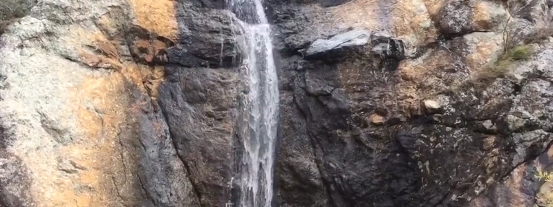
So-called “Hidden Falls” doesn’t appear on any park maps, but it is well-known to many of the park’s regular visitors. The falls are also known as “Dripping Springs”, a more descriptive term for typically drier years. Round trip distance to the falls is 4.2 miles, but there is little elevation change. The trail is level most of the way, with only a couple of short descents and ascents, and the end of the trail near the foot of the falls is only 300 feet higher than the trailhead parking lot.
From the large parking lot at the end of the park’s main road, the Canyon Loop trail leads to the Sutherland trail. The intersection with the Sutherland Trail is .75 miles from the trailhead, and this first section of the trail is mostly level, following the Sutherland Wash. If water is flowing in the wash, which is the case when the falls are flowing, the first two of three wash crossings can be avoided by turning left onto an unmarked trail just before the first crossing. This side trail parallels the wash and rejoins the main trail after the first two crossings, less than a quarter-mile from where the side trail originates, and just a half-mile from the trailhead.
At .75 miles from the trailhead, the Canyon Loop trail crosses the wash a third time, and a signed intersection with the Sutherland trail is half-way across the wash. This third crossing is usually easy since the trail intersection comes before the main water flow. A short stairway leads up to the left, beginning the Sutherland trail. From this point, it is two-thirds of a mile to the intersection with the Hidden Falls trail. The Sutherland trail is level at first, then climbs 30 feet to another long level stretch. Thoughtfully, a bench has been placed at the top of this short climb. At one mile from the trailhead, a loop trail intersects to the left. This loop trail, popular with wildflower enthusiasts, is unmarked, but a vertical metal Sutherland trail marker conveniently marks the spot. Continue beyond this for .40 mile to a second intersection, this time to the right. This is also unmarked but again is conveniently identified by another vertical metal Sutherland trail marker. This trail to the right is the Hidden Falls trail.
The trail heads east toward the mountains. It is relatively level, though it drops into and climbs back out of a small wash in less than a quarter-mile. This wash carries the water from Hidden Falls, and although it might be skimpy at the trail, the water at the falls will be flowing more heavily. After crossing this wash, the trail reaches a fork in a quarter-mile. The left fork leads to Hidden Falls, but hikers will want to take the right fork initially, in order to see the beautiful canyon and larger creek flowing through it. A sheer rock wall rises above the creek, and there are several viewpoints along this short, one-eighth mile spur. A second, even more hidden, the waterfall can be found just past the fork, though it is much smaller than the main falls.
Birders will enjoy this less-traveled area of the park. Cactus wrens, Pyrrhuloxia, Phainopepla, and Black-throated Sparrows are common in this area year-round, and spring brings many migratory birds, as well.
After checking the canyon, return to the split and take the left fork (to the right on your return). This narrow trail traces its way through a beautiful riparian area, following Hidden Falls creek, and ends at the creek, about three-tenths of a mile from the fork. The falls can be seen at several points along the way, but the best views are found at the end of the trail, where the 75-foot waterfall cascades down the cliff face above. This scenic spot is just over two miles from the trailhead, and hikers return along the same route.