
Mount Lemmon Day Trip
The Sky Island Scenic Byway from Tucson to Summerhaven is an easy way to beat the desert heat and to experience incredible and spectacular scenery along the way.
Mt. Lemmon rises more than 9,000 feet above sea level. This beautiful mountain is in the Coronado National Forest, and Tucson, Arizona’s backyard. When Tucson’s Sonora Desert temperature reaches 100 degrees, Summerhaven, just 25 miles distant, will be 30 degrees cooler.
Mount Lemmon Near Tucson, Arizona
Mt. Lemmon, at 9,157 feet, sits 6,600 feet above the Tucson airport. The Coronado National Forest peak is one of 15 “sky islands” that rise out of the Arizona and New Mexico desert. Its rugged cliffs, hoodoos, and spectacular vistas are a popular attraction for tourists, bikers, hikers, and nature lovers. It is also home to Summerhaven, a small mountain community near the summit, and Mt. Lemmon Ski Valley, the southernmost ski area in the United States.
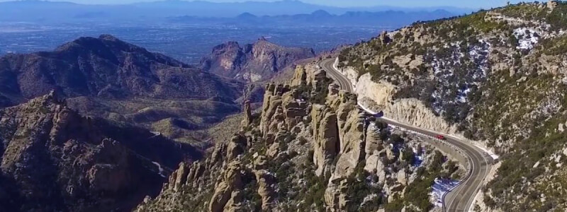
The 25 mile Sky Island Scenic Byway, or Catalina Highway, was completed in 1951 and winds upward from mile 0, at nearly 3,000 feet, to the road’s end at more than 9,000 feet. Six life zones are crossed along the way, equating the one-hour drive to a trip from Mexico to Canada.
Getting to the Mt. Lemmon Highway from Tucson
The Catalina Highway begins at an intersection with Tanque Verde Road in northeast Tucson. From downtown Tucson, take Speedway Boulevard east to Wilmot Road and turn north to Tanque Verde, which angles off to the right. Note that Pima Street turns left at this intersection. Follow Tanque Verde, which alternates northeast and east, about five miles to the intersection with the Catalina Highway. Once on the Catalina Highway, continue less than five miles to milepost 0 and the beginning of the Sky Island Byway.
Drive from Milepost to Summerhaven or Ski Valley
The Sky Island Byway is a paved, relatively safe, and modestly inclined road for the entire trip. It is well-signed, well-maintained, and there are frequent turnouts where slower cars can pull off to allow others to pass. There are many roadside parking areas at viewpoints, picnic spots, campgrounds, and other points of interest.
Bicyclists are common along the highway, and care should be taken to ensure their safety. The speed limit throughout the drive is 35 miles per hour, which is appropriate for dry daylight conditions but should be moderated on curves, at night or during wet weather.
A Coronado Recreation Fee Pass (five dollars) can be obtained at a feed station near milepost 5 and is required for anyone parking at vista points, picnic areas, or other facilities. Golden Age or Golden Access cardholders are exempt from this fee, provided that they display their card when parked along the way.
Just before the road enters Summerhaven, a small vacation home community, a side road turns right to Ski Valley, which is a couple of miles further. The Ski Valley road continues another mile and a half to a parking lot at 9,100 feet, near the mountain’s summit. Another road turns right from the main highway, just before the Ski Valley intersection, and is a 21-mile primitive road down the backside of Mt. Lemmon. This is a rough, rutted, and rocky road in spots, and not recommended for any vehicle other than those with high-clearance and 4-wheel drive.
Features and Attractions Along the Catalina Highway to Mt. Lemmon’s Summit
There are two vista pullouts in the five miles leading to the fee station, an area that is characterized by Saguaro cactus and other Sonoran Desert plant life. Beyond the fee station, the road continues a climb of 6,000 feet, and passes through six vegetative zones, equivalent to driving from Mexico to Canada. Roadside vegetation changes from cactus to grassland to oaks, junipers, Ponderosa pine, and, finally a mixture of pines, spruce, fir, and aspen. The temperature drops correspondingly as one ascends, and highs average 30 degrees less at the top than at milepost 0 during summer and fall.
There are eight campgrounds along the drive and nine designated picnic areas. Picnic areas are free (other than the required Pass). Campgrounds require separate fees for camping or day use, although these fees are discounted by half for Golden Age or Access cardholders. There are 11 named vista points, and many pullouts and other stops that are spectacularly scenic. The geology of the mountain is impressive and fascinating, as well. Precarious-looking balanced rocks and spires of eroded rock (Hoodoos) are found at Windy Point, Geology, and Hoodoo Vistas.
Rose Canyon Lake
Rose Canyon Lake is nestled in pines at 7,000 feet and stocked with trout. The lake is located at the far end of a managed campground, about 17 miles from milepost 0. The fee for day use of facilities, including the lake, is eight dollars, which is discounted to four dollars for Golden Age and Access holders.
The Palisade Visitor Center, above 7,000 feet, offers interpretive information, trail and other maps, and a national forest book store. When the drive reaches 8,000 feet, sweeping views are found at the Inspiration Rock picnic area, which is also one of many excellent birding sites.
The Summit Area on Mt. Lemmon
Just beyond milepost 24, a turn to the right leads to Ski Valley, while the main road continues into the community of Summerhaven. A lovely creekside picnic area, Marshall Gulch, is located at the end of Summerhaven. The Ski Valley road reaches a year-round ski lift and the Iron Door restaurant in less than two miles then continues another mile and a half to a parking lot and trailhead near the mountain’s top. Aspen paints the slopes golden in early October here, a beautiful contrast with the surrounding green fir and blue spruce.
Mt. Lemmon’s Sky Island Byway
The 25-mile highway from Tucson to Summerhaven offers a remarkable range of wildlife, geology, vegetation, and scenery. It’s also an easy way to escape the Sonora Desert’s summer and fall heat.