
25 Mile Catalina Highway Crosses 6 Vegetation Zones on Arizona Peak
When Tucson’s temperature reaches 100 degrees, residents often head up nearby Mt. Lemmon. A one-hour drive takes them to the conifer forests of Summerhaven, where the temperature is likely to be 70. Along the way, the Catalina Highway crosses five of Merriam’s six life zones.
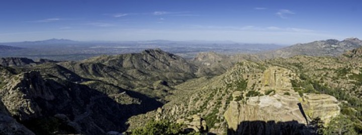
Mt. Lemmon in Arizona’s Coronado National Forest
Mt. Lemmon’s peak is 6,600 feet above Tucson’s airport, and 9,157 feet above sea level. The mountain is in the Coronado National Forest and consists of rugged cliffs, hoodoos, and spectacular vistas. Bicyclists climb the mile-high road daily, and the mountain is popular with hikers, birders, and camera-toting tourists, as well. There are many places to picnic, and the mountain provides eight campgrounds.
The small village of Summerhaven lies near the top, as does the southernmost ski area in the U.S., Ski Valley. The Catalina Highway, or Sky Island Scenic Byway, provides easy access to the peak on a gentle paved climb. The 25-mile drive climbs from 3,000 feet at mile 0 to more than 9,000 feet just beyond Ski Valley. This 6,000-foot ascent crosses six vegetation zones, as identified at the Palisades Visitor Center, essentially the same life zones that would be encountered on a drive from Mexico to Canada.
The Development of Merriam’s Life Zones
C. Hart Merriam studied the biological distribution of plants and animals in Arizona in the late 1880s. Merriam found that plant and animal species were relatively consistent through bands, or zones, that changed through increases in elevation or latitude. He identified six of these life zones, and then correlated these zones with changes in latitude from Sonora, Mexico, to the Canadian Arctic.
Mt. Lemmon’s Vegetation Zones Compared with Merriam’s Life Zones
The vegetation zones displayed at the Palisades Visitor Center differ slightly from Merriam’s, listing instead six zones found on the mountain and excluding Merriam’s highest, the Arctic-Alpine (now called the Alpine Tundra zone), which lies above timberline and Mt. Lemmon’s peak. The Lemmon zones include Sonoran Desert, Semi-Desert Grasslands, Oak Woodland and Chaparral, Pine-Oak Woodland, Ponderosa Pine Forest, and Mixed Conifer Forest.
Mt. Lemmon represents an ecological range that runs from the desert to a mixed conifer forest level shy of the highest recognized level, Alpine Tundra. The variation in vegetation and rainfall found on Mt. Lemmon is equivalent to that found in the latitude changes from Mexico to Canada’s fir forests.
The Sonoran Desert Vegetation Zone on Mt. Lemmon
Equivalent to Merriam’s Lower Sonoran Life Zone, this vegetation zone ranges from 3,000 to 4,000 feet above sea level, and has an average annual rainfall on Mt. Lemmon of approximately 11 inches. It is characterized by Saguaro and cholla cactus, Creosotebush and Ocotillo. This is the warmest area on the mountain, as well, and can be 100 degrees on a summer day when it is only 70 degrees 25 miles further up the road.
The zone, which extends throughout the city of Tucson, begins on the mountain road at milepost 0, and continues approximately 4 miles to the Molino Canyon Vista point, at 4,026 feet.
The Semi-Desert Grassland Zone on Mt. Lemmon
Running from 4,000 feet to 5,000 feet above sea level, the grassland zone is characterized by oak, juniper, and, naturally, lots of grasslands. The average rainfall in this zone runs about 14 inches. It is a bit cooler here than in the lower zone, but not much.
From Molino Canyon, this zone extends up the road about 3 more miles, where there is a 5,000 feet elevation sign just past the Big Springs trailhead.
The Oak Woodland and Chaparral Zone on Mt. Lemmon
The Oak Woodland zone covers a thousand feet from Big Springs trailhead to a point just past General Hitchcock Campground (5,800 feet), another 5 miles up the highway. Evergreen oaks, scrub oaks, manzanita, and buckthorn sagebrush are prevalent here, and annual rainfall averages 17 inches. The drop in temperature is noticeable once you enter this zone, where temperatures tend to run 5-10 degrees cooler than at milepost 0.
The Pine-Oak Woodland Vegetation Zone
A mix of pine and oak tree forests characterize this zone. Temperatures drop as one crosses this zone, from 6,000 to 7,000 feet above sea level. The 100 degrees at milepost 0 falls to 75-80 degrees in the pine-oak forests, and rainfall increases correspondingly, averaging 20 inches annually.
From General Hitchcock Campground, the highway winds through the Pine-Oak Woodland zone up to Rose Canyon Campground at 7,000 feet, another 5 miles up the road.
The Ponderosa Pine Forest Zone on Mt. Lemmon
This zone extends from Rose Canyon Campground at mile 17 to the Sykes Knob picnic area at mile 24, the longest stretch through one zone, and covers the elevations between 7,000 and 8,000 feet. Ponderosa pines forests are predominant throughout the area, and average annual rainfall increases to 23 inches. Summer temperatures tend to run about 25 degrees cooler than at milepost 0.
The Mixed Conifer Forest Vegetation Zone
From 8,000 feet above sea level to the mountain’s peak at 9,157 feet, the vegetation consists of mixed conifers including pines, firs, and spruce, as well as groves of Aspen. This area includes the junction with the 4-wheel drive road down the backside of the mountain to Oracle, the village of Summerhaven, and Mt. Lemmon Ski Valley. The road ends at a parking lot and trailhead above the ski area, at about 9,000 feet.
This is the coolest area on the mountain, where summer temperatures top out some 30 degrees less than Tucson, just 25 miles distant. Annual rainfall is highest here, averaging about 26 inches. The Mixed Conifer Forest zone covers the final mile of the scenic byway.
A 25 Mile Outing Equivalent to Driving from Mexico to Canada
The 25 mile Catalina Highway from Tucson to Summerhaven, at the top of Mt. Lemmon, is spectacularly scenic. It’s a great way to cool off on a hot desert day, and passes through the same vegetation zones that lie between Mexico and Canada.