
Saguaro National Park – Tucson, Arizona
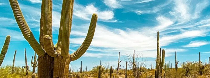
At the Saguaro National Park, you will experience the beauty of the towering saguaro cactus. The park covers approximately 91,000 acres and is filled with saguaro which are multi-pronged plants that can live more than 150 years! Some even grow to over 50 feet in height. There is also a teddy bear cholla, hedgehog, and a wide range of cactus for you to learn about and enjoy.
The giant saguaro cactus stands out as a symbol of the American southwest. However these spectacular plants are only found in the Sonoran Desert and only in a few sections of this desert. Saguaro National Park is one of those places. Saguaro National Park is located outside of Tucson, Arizona and protects forests of these unique and unforgettable cactus plants.
The Rangers at the visitor centers (there are two centers) offer a wide array of activities such from guided nature hikes to discussions about Saguaro’s unusual make-up of flota and fauna. The majority of these programs are scheduled from October thru April.
The park is divided into two distinct sections. The primary one on the east side of Tucson and a secondary one on the west side. You can visit both in one day but it would be a disservice to yourself to try to cram too much into one day, why not make a couple of days and see both areas in more detail?
Saguaro’s East Visitor Center is just off the Old Spanish trail, 15 miles east of downtown Tucson. The park’s Red Hills Visitor Center (the western one) is 20 miles west of downtown.
Tucson Mountain District. Saguaro West.
The Tucson Mountain District is also called Saguaro West. It has its own visitor center called the Red Hills Visitor Center which offers an orientation program about the Native American perspective on saguaros.
Hiking this district ranges from easy nature trails to rugged, switchbacks. Bring plenty of water as temperatures can exceed 100 degrees during the summer. Even in more temperate seasons, stay hydrated.
Equestrians and hikers share the Cam-Boh Trail. This 2.7 mile (one way) trail is a major connector between the east and west parts of the Tucson Mountain District.
A six mile gravel loop, Bajada Loop Drive, is an excellent loop for bicyclists. This is a scenic route through lower elevations and is open to vehicles, bikes and pedestrians.
Hundreds of ancient petroglyphs can be seen along the half mile Signal Hill Petroglyphs Trail. While rough in spots, this trail is relatively easy to traverse the rocky hilltop. A nearby picnic area makes a nice spot for enjoying a snack or picnic lunch.
Rincon Mountain District. Saguaro East.
Rincon Mountain District, also known as Saguaro East, offers numerous hiking trails, a fantastic saguaro forest and a scenic auto bike tour with stunning scenery and views of the Rincon Mountains. The Cactus Forest Loop Drive is open to bicyclists and cars and loops around for eight miles.
Cactus Forest Drive is a spectacular drive with numerous hiking trails designed to get you out of the car and amongst these magnificent saguaros. An easy stroll is the Desert Ecology Trail, a quarter mile round-trip paved trail that is wheelchair accessible and informative. You’ll be introduced to the plants and animals that live in the Sonoran Desert.
A one mile round-trip trail leads you to the Freeman Homestead where you can visit an old homestead site and see a grove of giant saguaros.
The Cactus Forest Trail is the only trail in the park designated for bicycle use. This is an easy trail shared by hikers, bicyclists and livestock that ranges from 2 to 3 miles round trip depending on your access spot.
Access to the Saguaro Wilderness Area in the Rincon Mountain District is available for camping by permit. In addition, livestock defined as donkeys, horses and mules are permitted here. Over 100 miles of trails open to livestock use are available in the 57,000 acre wilderness. The wilderness encompasses desert, grassland, oak woodland, pine forests and mixed conifer forests.
Short Hikes
On the east side, there are a couple of quick hikes you can take along the 8-mile park loop road, Cactus Forest Drive, the quarter-mile desert Ecology Trail with its informative signage to help you identify the species. On the west side, you can take the .8 mile Valley View Overlook Trail (which is off the 6-mile Bajada Loop Drive) for a spectacular view of the desert.
Tanque Verde Ridge Trail
For those of you that want a more challenging hike, Saguaro has a number of rather ambitious trails for you to try. These are primarily on the eastern side. The Tanque Verde Ridge Trail is truly a rewarding hike to the elevation of 7,000 ft!
Saguaro Wilderness Area
You may enjoy the Saguaro Wilderness Area which is a large, road-less backcountry area consisting of 57,930 acres within Rincon Mountain District. It is bounded on three sides by the Rincon Mountain Wilderness Area which is part of the Coronado National Forest.
The plant communities in the wilderness area consist of plants from hot and dry desert scrub to cool and moist pine forests. There are six different biotic communities which are represented including desert scrub, desert grassland, oak woodland, pine-oak woodland, pine forest, and mixed conifer forests.
Operating Hours & Seasons
Both districts of the park are open from 7:00 a.m. to sunset daily. Both districts of the park offer a visitor center with operating hours of 9:00 a.m. to 5:00 p.m. daily, except closed on Christmas Day.
Entrance Fees
Entrance fees are charged to enter either district of Saguaro National Park.
$10.00 for any privately owned vehicle or motorcycle – the receipt is valid for 7 days
$5.00 for any individual on foot or bicycle – the receipt is valid for 7 days
Hours: 7:00 AM to sunset daily, year round.
The entrance fee at both districts of the park is $10 per vehicle and is valid for 7 days. Bicyclists, motorcycles and pedestrians get in for $5, also valid for 7 days.
Both visitor Centers are open from 9:00 to 5:00 daily. Closed on Christmas Day.
Passes
Locals may be interested in purchasing an annual pass to Saguaro National Park for $25. They can come and go all year long with this pass.
A National Parks Pass for $50 allows access to all National Parks for a term of one year from the month of purchase.
U.S. citizens or permanent residents over age 62 are eligible to purchase a $10 Golden Age Passport which allows access to National Parks for life.
Permanently disabled U.S. citizens or permanent residents are eligible to receive a free Golden Access Passport allowing free access to National Parks for life.
How to Get There: Traveling By Car
Getting to the Rincon Mountain District from the City of Tucson
Travel east on Broadway or Speedway Boulevard to Freeman Road (turn right on Freeman Road). Drive south on Freeman Road (4 miles [6.5 kilometers] from Speedway, 3 miles [5 kilometers] from Broadway) to Old Spanish Trail. Turn left on Old Spanish Trail. Drive .25 miles (.4 kilometers) southeast on Old Spanish Trail to the Park entrance on the left side of the road.
Getting to the Rincon Mountain District from Interstate 10
Primary Route from I-10
Exit I-10 at exit # 275 (Houghton Road) and drive 9.5 miles (15 kilometers) north to Old Spanish Trail and turn right. Drive 3 miles (5 kilometers) southeast on Old Spanish Trail and the park entrance, which will be on the left side of the road.
Alternate route from I-10
For a more scenic alternate route, take exit #279 (Colossal Cave Road) and go north for 3.5 miles (5.5 kilometers) to Pistol Hill Road and turn left. Drive 2 miles (3 kilometers) northeast on Pistol Hill Road to Old Spanish Trail and turn left. Proceed north on Old Spanish Trail 11 miles (17.5 kilometers) to the park entrance, which will be on your right.
Getting to the Tucson Mountain District from the City of Tucson
Travel west on Speedway Boulevard. At the junction of Camino de Oeste, Speedway Boulevard will change names to Gates Pass Road. From this junction, drive 4 miles (6.5 kilometers) west on Gates Pass Road until it ends at Kinney Road (turn right on Kinney Road). Drive 3 miles (5 kilometers) north on Kinney Road to the Park entrance (entrance will be on the right side of the road). This route is not suitable for vehicles over 25 feet in length.
Getting to the Tucson Mountain District from Interstate 10
Primary Route from I-10
If you are traveling eastbound, there is one direction sign at Exit # 242, which is called the Avra Valley Road. Drive 5 miles (8 kilometers) west on Avra Valley Road to Sandario Road (turn left on Sandario Road). Drive 9 miles (14.5 kilometers) south on Sandario Road to Kinney Road (turn left on Kinney Road). The visitor center is 2 miles (3 kilometers) down Kinney Road on the left side of the road.
Alternate Route from I-10
Take exit #248, which is called Ina Road and drive west 2.5 miles (4 kilometers) to Wade Road and turn left. Drive .6 miles (1 kilometer) to a big curve. At this point, Wade Road will change names to Picture Rocks Road. Drive 6 miles (10 kilometers) west on Picture Rocks Road to Sandario Road and turn left. While on Picture Rocks Road you will enter and exit Saguaro National Park. Drive 3.5 miles (5.5 kilometers) south on Sandario Road to Kinney Road and turn left. Drive 2 miles (3 kilometers) down Kinney Road to the visitor center, which will be on your left.
Getting to the Tucson Mountain District from Interstate 19
Interstate 19 is a rather short route beginning in Tucson at Interstate 10 and going south to the border of Mexico at Nogales, Arizona. Take I-19 south to Ajo Way (exit 99) then go west on Ajo Way (also known as Highway 86) to Kinney Road and turn right and head north, follow the signs to the park.
Headquarters & Rincon Mountain District
Saguaro National Park
3693 South Old Spanish Trail
Tucson, AZ 85730-5601
– or –
Saguaro National Park-Tucson Mountain District
2700 North Kinney Road
Tucson, AZ 85743
By Phone
Visitor Information – Rincon Mountain District (520) 733-5153
Visitor Information – Tucson Mountain District (520) 733-5158
Headquarters (520) 733-5100